The Ride
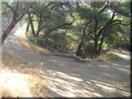
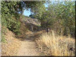
 Start by going North on Loraine Avenue, reaching the Colby Trail head at 0.18 miles. This first trail is a short but fairly steep single track that serves as a shortcut to Glendora Mountain Road and is a fun warm up. At 0.4 miles you come to a junction. It does not matter which way you go as both paths reconnect, but for this description I went straight ahead. Doing the same you will see at 0.66 miles a gate on your right - that’s where the other path rejoins. At 0.74 miles you reach a seat and some nice views of the valley and after passing another junction at 0.86 miles we connect to the Glendora Mountain Road at 0.91 miles were you turn left to begin the gradual ascent on pavement. Start by going North on Loraine Avenue, reaching the Colby Trail head at 0.18 miles. This first trail is a short but fairly steep single track that serves as a shortcut to Glendora Mountain Road and is a fun warm up. At 0.4 miles you come to a junction. It does not matter which way you go as both paths reconnect, but for this description I went straight ahead. Doing the same you will see at 0.66 miles a gate on your right - that’s where the other path rejoins. At 0.74 miles you reach a seat and some nice views of the valley and after passing another junction at 0.86 miles we connect to the Glendora Mountain Road at 0.91 miles were you turn left to begin the gradual ascent on pavement.
This is a great section for road cyclists as the grade is fairly constant, but a mountain bikes gears can put you at an advantage compared to the high gearing of many road bikes so spin away and expect to pass and be passed by others! At 3.75 miles the Glendora Ridge Motorway fire-road is on the left. I once ventured down there and was rewarded with more thorns in the tires than I had patches. There are few options if you take this road - the exit in Azusa is fenced off with a very tall chain linked fence. There is a single track midway that will put you out at the fire station on Sierra Madre Ave (North of Rosedale) but it’s a steep single track that I don’t recommend attempting to ride. At 7.8 miles you reach a forest service building - a common rest and turn around point for many of the road cyclists not going on to Baldy village.
 Finally at 8.08 miles we turn right onto the fire road. The fire road North is the upper Monroe Road which apparently connects to East Fork road, although I’ve never taken it that far. Instead we take the Lower Monroe Road passing to the right of the gate at 8.14 miles. Finally at 8.08 miles we turn right onto the fire road. The fire road North is the upper Monroe Road which apparently connects to East Fork road, although I’ve never taken it that far. Instead we take the Lower Monroe Road passing to the right of the gate at 8.14 miles.
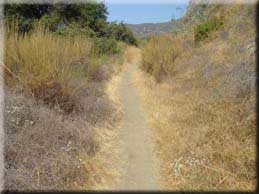
Even in July the upper part of this trail was shrouded with tall grasses, albeit dry. It’s single track almost all of the way, and while it can appear overgrown from a distance it’s not hard to follow the path. At 8.73 miles pass a turnoff on the left (once lead to beehives). There follows a short but tough climb which you crest at 9.38 miles (after passing another turnoff on the right).
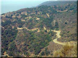
At 11.12 miles there is a nice viewing point and another one at 12.95 miles. From here you can easily see why the Glendora Mountain Road we climbed earlier is so popular with motorbikes, road cyclists and even skateboarders. Although the road has lots of switchbacks they are perfectly banked to allow riders to carry some speed into the corners. Also from here you will see single tracks taking off into the Dalton Canyon area. These are steep and best left to hikers unless you are especially skilled with brakes and balance.
 Continuing on Monroe Road you will know the river bed is approaching by the increasingly green and dense vegetation. At 13.63 miles be warned there is a dip that you may be able to ride into but will need to walk out. It’s easily traversed on foot, but after heavy flooding a couple of years ago it was barely passable for many months. I doubt the path will ever be fully restored here as it obviously crosses a significant watershed. Continuing on Monroe Road you will know the river bed is approaching by the increasingly green and dense vegetation. At 13.63 miles be warned there is a dip that you may be able to ride into but will need to walk out. It’s easily traversed on foot, but after heavy flooding a couple of years ago it was barely passable for many months. I doubt the path will ever be fully restored here as it obviously crosses a significant watershed.
 At 14.51 miles we reach the bottom of the road and turn left to pick up a single track route along the river bed. The many rounded and loose rocks together with plants and water (depending on season/rains) make this section an engaging and fun challenge. I always expect to dab a bit so unclip for this section but it’s all rideable with patience, balance and a little leg power. At 14.51 miles we reach the bottom of the road and turn left to pick up a single track route along the river bed. The many rounded and loose rocks together with plants and water (depending on season/rains) make this section an engaging and fun challenge. I always expect to dab a bit so unclip for this section but it’s all rideable with patience, balance and a little leg power.
At 15.34 miles you reconnect with Glendora Mountain Road and turn left for an easy spin back to the start. To return I recommend taking a right on E Palm Drive and continuing to the end of the road. Instead of following the road as it veers left you can continue straight alongside the chain-linked fence using a short off-road path to reconnect with Loraine Ave and the ride start.
|

